Long-Distanced Journey
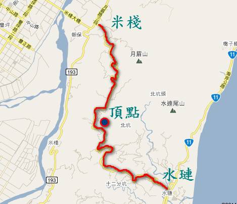
Mizhan Trail
Zen Ting
Introduction of the Journey:
This route uses Hualien County Road 38-1. The length is 13.4 kilometers. It originally belonged to the Ami and ShuiLian tribes. Before the opening of Taiwan 11, the most direct way to go to the ShuiLian tribe was to go through the coastal mountain range. Since Taiwan 11 opened people no longer have to use this old road and now it is used as an commercial road.
The first third of this route has a gradual slope so you can enjoy the natural surroundings. One kilometer before you reach the peak, the slope becomes steeper and is the most challenging part. At the peak you'll be at the corner of the coastal mountain range. You can see the ShuiLian tribe from the peak as well as the FengTian community and the fatigue of the uphill trip will disappear. From there the rest of the journey is all downhill. Because this road is used commercially, control your speed as you go down to ensure a safe journey.
Route Planning
- urn right at the ShuiLian intersection and go 72 meters
- urn left at the first intersection, take Hualien County Road 38-1 for 800 meters
- At the first intersection, turn right and continue for 3.9 km on Hualien County Road 38-1
- Turn left, continue to take Hualien County Road 38-1 for 800 meters
- Turn right, continue to take the Hualien County Road 38-1 for 3.9 km
- Turn right, continue to take the Hualien County Road 38-1 for 2.7 km
- Turn right, continue to take the Hualien County Road 38-1 for 2.7 km
Elevation
- Starting Point: 23 m
- Highest point: 455 m
- Finish: 62 m
The difficulty of this trail:*****
Notice:
- Know whether you can bear the challenge before starting off.
- Prepare more food and water since there are no stores on the way.
- Warm-up and eat a banana in case of having spasm when you are riding.
- Be care of the light when going through the tunnels.
- Don't insist to climb up the road in case of hurting yourselves and bikes.