
Known Huaien
The natural landscape
Si Hua
 Hualien locates at the east of the Central Mountain Range and the west of the Pacific Ocean, with Yilan County at the north and Taitung County at the sourth. Although Hualien is the largest county in Taiwan, the mountainous landforms limit the areas of plains. Most of the population reside on the plain areas. In the Huatung Valley, rivers bring soils from the mountains and form piedmont alluvial plains.
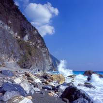
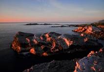 The length of the coast is 124Km, The rivers form various seacoast landscapes and the cliffs are the most dangerously steep. The Taroko National Park is also very well-known. The Chingshui Cliff at the southern part of Heping River is higher than 1000 meters, is a famous scenic area on Suhua Highway. However, the highway is easily broken by the rain. Shimen locating at the south of Hualien contains hard coral reefs with many special landscapes caused by marine abrasion. Travel toward south is Shitiping, where rocky terrains stretches into the ocean, and a lot of sea trenches, sea cliffs, wave-cut platforms, and uplifted coral reefs, and the potholes, in particular, can be called the top one site in Taiwan. Because of the crooked landforms, Hualien is full of various types of natural landscapes.