| |
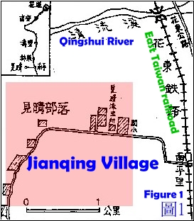
Jianqing
Village (Miharasi) is
located in the
north
Wanrong Township and at
the west foot of Huatung
rift Valley, abutting
Fengling Nanpingli in
the east, next to
Fenglin Mt. in the west,
and fronting Qingshui
River in the north,
which is the border of
Jianqing Village and
Linrongli of Fengli
Village. The village
consists of two parts,
one near Jianqing
Substation and the other
at the foot of Fenglin
Mt., with residents
sporadically, which was
under the supervision of
Fenglin Section, named
as “Jianqing Village”,
and was transferred to
the supervision of
Wanrong Townshiop as a
village in June 1946,
named as original “Jianqing”.
Main members of the
community come from Kebayan area, the
descendant of Awi
family. In June 1914,
Japanese army occupied
the area and set up two
“Garrisoning Stations”,
one in Kebayan
supervising Tongkalao,
Uway, Luweng, Pokabalas
and Kebayan, and the
other in Batoluf
supervising Batoluf and
Lupo. The Japanese named
Batoluf as “Jianqing”
because of
the aerial
hypsography and the
far-flung landscape,
which is adopted as the
name while the village
moving to current
location.
  |
|
|
Kebayan Village resided
in high platform under
Chungheng Road New
Baiyan
Station (13 mark
of Chungnheng Expressway
8), after change, which
was divided into two
villages, Kebayan and
Uway. Uway villagers
later moved to Qauan
community in Shioulin
Township leaded by Siyup
•Umaw. One branch of
Kebayan also moved down
to places of the same
town, Delugu, Gulu,
Daolas and Jiashan. The
rest of Kebayan growed
in population later and
moved to current
location Jianqing
Village leaded by chief
Luxinbakelu, which
stoped moving after the
region recovered.
Kebayan Area --- the
residental area of Awi
Family
Kebayan Area is the
coteau between Luweng
River and Xiao Wa Hei Er
Brook, the branch of
Liwu River, starting
from Mantou Mt. in the
east and ending at
Central Mountains in the
west, key tribes of
which are located around
hillside of Kebayan, the
area Awi family resided.
Awi
originally lived in Saso
(current Jingguan,
Nantou County Renai
Township), having three
sons and a daughter. His
daughter (Bonga)
returned to her
birthplace with her
children after her
husband died. Soon
after, Lausi was elected
as the leader after
discussed by Bonga,
Lausi and Pixo, to
migrate the family to
fertilized land as a
measure solving the
problem of plowland
short, where is New
Baiyang area at present,
as well as the initial
colonized base of Awi
family.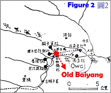
Ulay is located in lower
part, west to New
Baiyang, on the
arrisways of bank
intersection of Liwu
River and Luweng River.
Three sides of the area
are surrounded by rivers
with mountain at back,
and places fronting
brook are cliffy, which
would be a safe
residental location with
prominent advantage in
guarding. To the second
descendant, tribespeople
started to migrate to
places nearby because of
population increase and
plowland shortage.
Initially, Payan, the
son of Bonga, moved to
the mesa and built a new
community on the bank
east to Ulay with
1-kilometer distance,
which was called as
“Skobayan” by the
members to memorize Payan after he died,
because he was brave,
strong, generous, and
respectable. Now the
community is called as
“New Baiyang” with
slight change in
pronunciation.
 About 30 years after
establishment, Umaw, the
son of Pixo•Nauyi,
leaded family members to
move from Ulay to rocky
“Batoluf”, a place 2
kilometers away,
southwest to the
original residental
location.
At the initial
stage of Japanese
occupation, the
commanding village was
located in mountainside,
therefore named as
“Jianqing” that means
“prospecting”. Till the
fourth era, Awi family
had established 8
villages in Kebayan
coteau in succession,
each of which had their
own leader to manage
routine affairs and
would co-elect a super
leader as the chief in
charge of command
responsibility and
against external
invasion. When Japanese
army attacked Truku in
June 1914, Uming•Pakul
was elected as the chief
leader of Kebayan area
to lead local force
against Japanese
soldiers, during which,
fierce fighting occurred
in Batonox-Daya, east to
Luweng, when Japanese
could not conquer the
area but succeeded later
by attacking with two
groups.
About 30 years after
establishment, Umaw, the
son of Pixo•Nauyi,
leaded family members to
move from Ulay to rocky
“Batoluf”, a place 2
kilometers away,
southwest to the
original residental
location.
At the initial
stage of Japanese
occupation, the
commanding village was
located in mountainside,
therefore named as
“Jianqing” that means
“prospecting”. Till the
fourth era, Awi family
had established 8
villages in Kebayan
coteau in succession,
each of which had their
own leader to manage
routine affairs and
would co-elect a super
leader as the chief in
charge of command
responsibility and
against external
invasion. When Japanese
army attacked Truku in
June 1914, Uming•Pakul
was elected as the chief
leader of Kebayan area
to lead local force
against Japanese
soldiers, during which,
fierce fighting occurred
in Batonox-Daya, east to
Luweng, when Japanese
could not conquer the
area but succeeded later
by attacking with two
groups.
The
tribespeople residing in
places of Truku and
Batolan were forced to
move to Wanrong Township
under Japanese rule, as
a measure that the
authorities adopted to
prevent from snipe at
Japanese police and
occurance of turmoil,
from when, the villages
were founded gradually. |