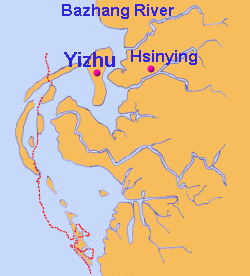
Taiwan Tilapia

Site Map | Hometown | History | Breeding | Food Processing | Recipe | Work Report | Narrative


To know Taiwan Tilapia

Geographic Location

The Ancient Map

Eye in the Sky

The Unique Scenery of Fishing Villages

Distinguished Guests from the North

Life Proverbs


 The Ancient Map


Tree hundred years ago, the Yizhu Township (Er-Zhu-Wei), located near the estuary of Bazhang River, was only a small island of the Lagoon. As time went by, the surrounding shallow sea was silt up and became the land. The coastline moved outside, and then fish farms and saltpans were developed. From the map of Zheng Cheng-gung period, we can realize the development steps of our ancestors. According to the above-mentioned map, the blue line means the coastline in early days, and the red dotted line means the coastline nowadays.

The Ancient Map

The Geographic Location of Yizhu Township Three Hundred Years Ago

Drawn by The Naughty Smart Group

Copyright c 2007 , The Naughty Smart Group. Yizhu Elementary School, Chiayi County, Taiwan. All rights reserved.