|
Kaohsiung Geography
|
一、Kaohsiung
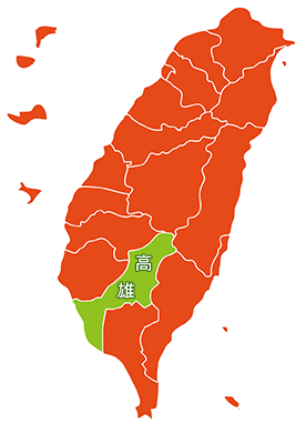
| Kaohsiung is located in southwestern Taiwan. It is one of the six municipalities directly under the Central Government of the Republic of China and the third largest city in Taiwan. Today, the area of Kaohsiung administrative area is 2946.2671 square kilometers, and the total population is about 2.77 million [1]. There are 38 administrative regions, of which 11 belong to the former Kaohsiung city and 27 belong to the former Kaohsiung county. The area of high mountain land in Kaohsiung is 1555.0398 square kilometers (52.78%), and the area of hills and plains is 1391.2273 square kilometers (48.22%). The city occupies 8.14% of the country [2]. The longitude and latitude of Kaohsiung City are 22 ° 28 'to 23 ° 28' N. East longitude 120 ° 10′32 inches to 121 ° 01′15 inches. In addition, the Dongsha Islands are located in the southwest of Taiwan's main island. Latitude and longitude positions are 116 degrees 24 'to 116 degrees 55' east longitude and 20 degrees 35 'to 47' north latitude. The longitude and latitude of Dasha Island in the Nansha Islands is 10 degrees 22 minutes north latitude. East longitude 114 seconds 21 minutes 59 seconds. |
 |
二、Geographical environment of Kaohsiung Geography
| Population |
About 2.77 million |
| Area |
About 2951.8524 square kilometers |
| Geogra phical location |
Kaohsiung is adjacent to Hualien County and Taitung County in the east, to Taiwan Strait in the west, Linyuan District to Pingtung County in the south, and to manage Dongsha Island and Nansha Taiping Island in the South China Sea, and to the north of the Yushan Peak in Taoyuan District, adjacent to Chiayi and Tainan. |
| Climate |
Tropical monsoon climate |
三、District of Kaohsiung City(District)
四、City flag city emblem
五、Kaohsiung Sanshan
| The three mountains of Kaohsiungn, that is means refers to the three areas of Gangshan Dst 、Fengshan Dist、Qishan Dist in Kaohsiung, Taiwan. Old Kaohsiung CountyKaohsiung's county emblem is a symbol of "three mountains in one". |
六、Kaohsiung City Flower (Kapok)
|
Data collection: Zhang Anyan |
|