|
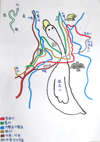
Pingding Ancient Trail is located on the side of Chi-Sing
Mountain series in Shilin District, Taipei City. The total length is
about 2.3 kilometers with average slope of 3~7 degree. The entire trail
takes about 1 hour and 15 minutes to complete. There are two mountain
hiking entrances to the trail, one up from Zhishan Road and the other
one down from Lane 95 of Pingjin Street in Pingding Village. Each
Channel is accompanied by walking trail, forming the three centennial
waterway ancient trails. The three Channels excavated from one hundred
years ago all were built from high lines in Majiao Mountain and Erwei
Mountain. The most difficult part was the mountain excavation and caves
for the Channel to Pingding settlement at Jiaokeng Creek.
The three Channels of Pingding were built rom along the high lines of
Majiao Mountain and Erwei Mountain Range. The ancestors also renovated
the trail in the process of building Channels.
(n)
Pingding ancient Channel Trail is approximately located in 300~500
meters above sea level with a total trail length of about 2.3 kilometers
with slope averaging between 3~7 degree. The entire trail takes about 1
hour and 15 minutes to complete. Around the Qinfong Pavilion is the
highest point in Pingding Ancient Channel Trail, where tourists and walk
down further along the granite trail.
(m)
Moreover, a border monument for Yangmingshan National
Park was set up at the entrance to Pingding Ancient Channel Trail, and
the region after the border monument is administrated under the National
Park. This trail currently belongs to one of the branch in Yangmingshan
National Park Qingtiangang Trails.
Pingding Ancient trail penetrates Pingding Old Canla, New Channel and
Dengfong Channel. The sites passed are in the order of Pingdeng Village
Trail Entrance (height 445 meters) )→Qinfong Pavilion (height 470
meters)→Taozijiao Bridge (height 365 meters) →Tiaweizi Bridge (height
310 meters) → Zhishan Mountain Hiking entrance (335 meters) →Pingding
Ancient Channel Trail entrance station (height 260 meters)(m)。
This connection of this trail shows the close and
undertaking relationship of irrigation among the three Channels.
|