
History of the Nanyang Street
| Terms and Definition |
| Composition of “Cramming” Students |
| Digitalization of Buxibans |
| Traffic Conditions around the Nanyang Street |
| Thriving Businesses on the Nanyang Street |
|
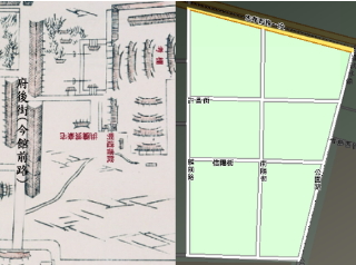
The Nanyang Street ( Here for its location) , synonymous with “cram” culture in Taiwan , is renowned both domestically and internationally. BBC once covered the math education in Taiwan , and the Nanyang Street was featured in that story, which introduced to the world its peculiar buxiban culture. Through cross-reference between a map in the past and that of today, it is evident when the Nanyang Street showed up. The map of Taipei City drawn in the Qing Dynasty has only the Fu-Hou Street (the Guan-Qian Road today), while the Nanyang Street was yet to be drawn.
|
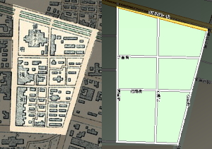
The birth of the Nanyang Street dates back to the period of Japanese administration. After the implementation of urban planning, roads were widened, and from the map in 1914, it is not hard to tell the similarity between the blocks around the Nanyang Street and those of today. Though the Nanyang Street was not named then. After the recovery of Taiwan from Japanese rule (1945), this street was named “Nanyang” after the Nanyang County in He-Nan province (in china) in 1947.
Page 1 2 |
Copyright © 2007 CKHSC1st. All rights reserved.